
Englewood Agro-Eco District Land Use Plan
The Englewood Agro-Eco District land use plan was created by the Department of Planning and Development (DPD) in collaboration with community organizations seeking to improve properties adjacent to the planned 1.75-mile Englewood Nature Trail. The land use plan is the product of community meetings led by Grow Greater Englewood and a team of consultants led by Gensler, a global architecture firm in Chicago.
Feedback collected from design exercises, roundtable discussions and neighborhood presentations informed the proposed land uses. DPD thanks the hundreds of meeting participants who contributed their time and ideas to this process.
Guiding Principles
In March 2023, Englewood residents established a list of guiding principles for the plan.
Community First: Honor, reflect and build from the rich history of Black culture and the current Black residents of Englewood and West Englewood that ensures accountability and community sustainability.
Strength: Preserve and enhance the resiliency of natural habitat along the trail, within adjacent areas and among residents.
Health and Security: Create an agro-eco district and trail that follows an agroecology approach to improve health-related social determinants of area residents by providing a safe place to work, heal, play, celebrate and grow food.
Stabilize: Position the land surrounding the trail to provide a sustainable future and economic security for the current residents of Greater Englewood by providing opportunities to create generational wealth via community investment and by stabilizing housing.
Pathways for Work and Wealth: Provide economic, educational and career opportunities for residents through the planning, design, remediation, construc tion and management of the public land and throughout the Englewood Agro-Eco District.
The guiding principles informed the creation of the land use plan's map, below.
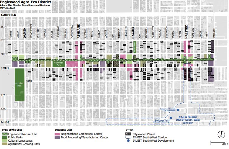
Land Use Map
The map includes two main components: open space and business uses.
The open space uses include the following components and definitions.
Englewood Nature Trail: The elevated railroad embankment and associated at-grade access points that will be developed by the Chicago Department of Transportation and managed by the Chicago Park District.
Parks: The existing Lindblom, Hermitage and Moran parks, which are owned and managed by the Chicago Park District.
Cultural Landscapes: Community-oriented spaces that could be publicly managed, including three major spaces that would serve as activity hubs for a mix of uses:
- Halsted Street: Currently used for parking, outdoor materials storage and retail.
- Damen Avenue: Currently used to store vehicles.
- Racine Avenue: Managed as a Chicago Public Schools campus park and vacant City-owned land.
The business uses include the following components and definitions.
- Agricultural Growing Sites: Existing urban farms owned and operated by Growing Home, NeighborSpace and Grow Greater Englewood, as well as vacant land identified for agriculture.
- Neighborhood Commercial Centers: Land and buildings appropriate for business uses, including restaurants, markets, food education facilities, retail, services and mixed-use buildings.
- Food Processing and Manufacturing Centers: Land and buildings appropriate for larger-scale business operations such as for-profit agriculture, food processing and food distribution.
A land use plan is a planning tool that identifies how a collection of properties should be used, with specific recommendations for each type of use. For example, a plan can identify sites for housing, retail, open space or other uses. Land use plans are created through a community-driven process that considers past and current uses of each property, along with local goals and market trends that help determine if the current uses should be maintained or changed. Land use plans are represented by land use maps that identify a community’s desired uses for an area.
Land use plans formalize a community’s goals for a given geography, such as an intersection, a corridor or an entire neighborhood. The formalized goals establish expectations about potential improvements for the property within the plan’s boundaries. In Chicago, land use plans can be presented for approval by the Chicago Plan Commission, which is an advisory group of elected officials, City department heads and private citizens. Land use plans adopted by Plan Commission help ensure that proposed construction projects or other improvements match the community’s vision for a specific site.
Land use plans do not impose requirements on property owners. Land use plans simply represent a community’s vision for how properties within the plan’s boundaries should be used. Land use maps are different than zoning maps, which indicate what types of uses are lawful on a given site. While zoning maps reflect the legal rights and responsibilities of individual property owners in terms of how a site can be used or improved, land use maps have no regulatory authority.
The land use plan would support the trail by creating a framework for an “agro-eco” district along its length. The agro-eco district envisions ecological, agricultural, and business uses for vacant land next to the trail. The trail is planned as a multi-use path that would utilize 1.75 miles of a former Norfolk Southern railroad right-of-way that runs parallel to 59th Street between Hoyne and Wallace avenues. The right-of-way is owned by the City of Chicago.
The properties adjacent to the trail include a mix of City owned and privately owned sites that are primarily vacant. Select properties along the trail have the potential to be used for ecological and agricultural purposes that were envisioned in the “Green Healthy Neighborhoods” plan, which was adopted by the Chicago Plan Commission in 2014.