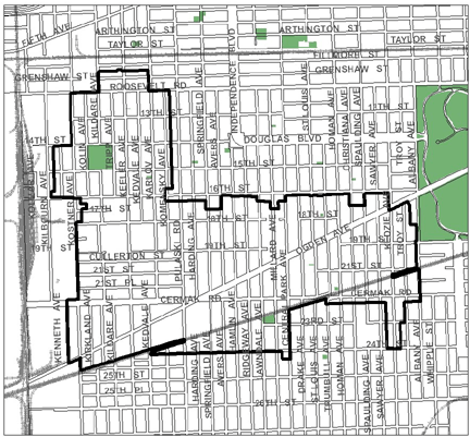
Ogden/Pulaski TIF

Designation: 2008    Expiration: 2032


The Ogden/Pulaski TIF district is intended to provide redevelopment resources for a large portion of the North Lawndale community and a smaller area in the South Lawndale community. The 876-acre area is characterized by residential, commercial, and mixed-use structures and numerous vacant lots. The TIF is designed to promote new commercial development along Ogden Avenue and other arterial streets, mixed-income residential investments on area side streets, and transit-oriented development near the area's rapid transit stations. It's also designed to help create new roadways, utilities and other infrastructure projects, and to support open space expansion efforts that benefit local residents and workers. Job training, day care and relocation assistance programs are also supported by the TIF.


Redevelopment Plan (PDF)
Designation Ordinance (PDF)
Annual Report (PDF)
Projection Report (Data Portal)


Ogden/Pulaski TIF district map, roughly bounded on the north by Fillmore Street, 25th Street on the south, Albany Avenue on the east, and Kilbourn Avenue on the west.

PROJECTS

Montclare Senior Residences SLF of Lawndale

Supporting Information Facts