
Community Plans
|
DPD's Planning bureau maintains a list of updated Community Plans that guide development in targeted Chicago neighborhoods. Comments on existing plans can be emailed to DPD@cityofchicago.org. |
Past Community Plans
Adopted in 2022, the Western Avenue Corridor Study is a community-based planning initiative to envision an equitable, long-term future for a five-mile section of North Western Avenue, from Addison Street to Howard Street.
Adopted in 2022, the Western Avenue Corridor Study is a community-based planning initiative to envision an equitable, long-term future for a five-mile section of North Western Avenue, from Addison Street to Howard Street.
Adopted in 2023, the Clark Street Crossroads Study included robust analysis and community engagement to determine opportunities, constraints, and priorities for development, programming, and public realm improvements along the corridor.
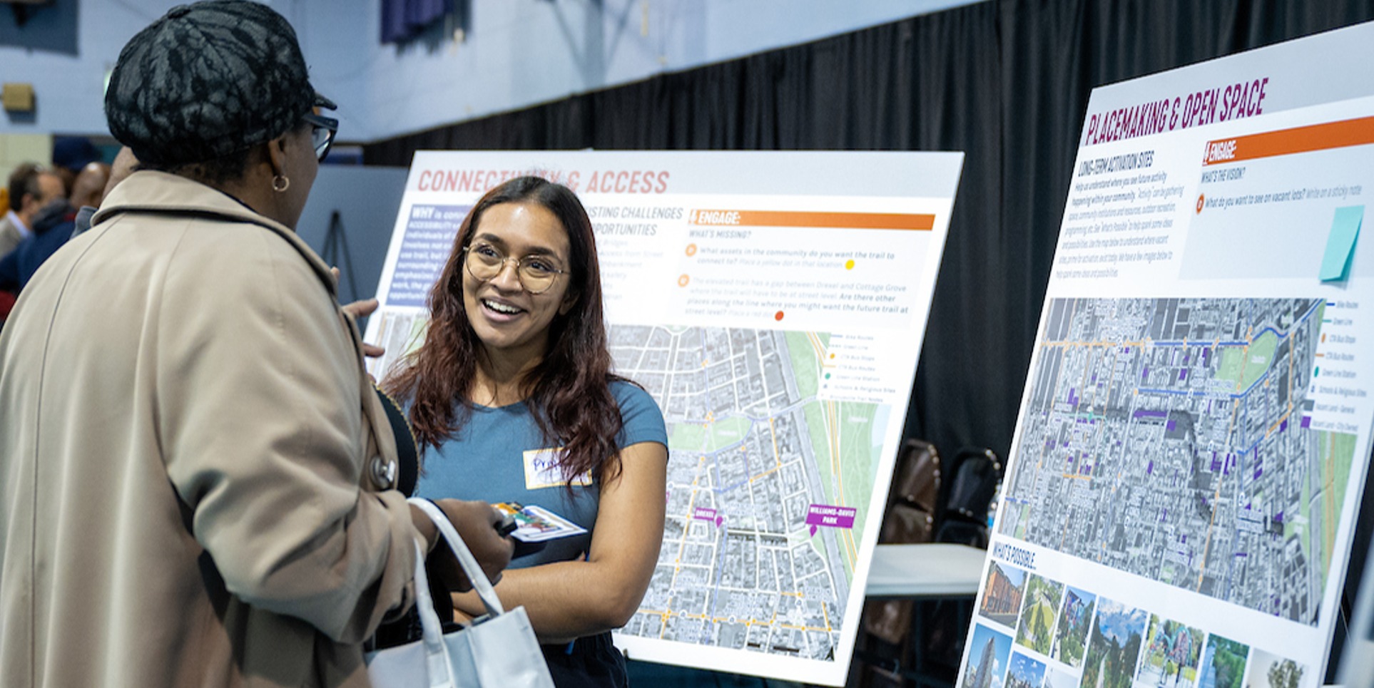
Adopted in 2023, the Red Line Extension Transit-Supportive Development Plan is a proactive effort to create a guide for future development in the long-disinvested communities located near the RLE project area.
Completed in 2017, the document is meant to assist the Gladstone Park Chamber of Commerce and the Gladstone Park neighborhood to guide future development and growth in this corridor.
Adopted in 2017, the North Branch Framework is a plan for 760 acres along the Chicago River between Kinzie Street and Fullerton Avenue, and it's the first framework developed as a part of of the Industrial Corridor Modernization Initiative, a multi-year effort to review Chicago’s designated industrial corridors.
Adopted in 2017, the West Loop Design Guidelines add to previous planning efforts to ensure that the West Loop continues to build on the central area characteristics as an employment, transportation, cultural and residential center for the city.
Adopted in 2018, the plan is intended to capitalize on transit investments by encouraging the thoughtful development of the area surrounding the Jefferson Park Transit Center on the Northwest side.
In spring 2019, the Department of Planning and Development completed a market study of commercial corridors in the North Park neighborhood, primarily along Foster Avenue, Bryn Mawr Avenue and Kedzie Avenue. The study is a reference guide that can be used by local businesses, potential investors and residents.
Adopted by the Chicago Plan Commission in February 2019, the Ravenswood Framework offers recommendations that focus on utilizing existing resources, incentives and programs to support the changing needs of existing and new businesses in the Ravenswood Industrial Corridor on Chicago's North Side.
Learn More
Adopted in 2010 and updated in 2020, the Halsted Triangle plan is intended to generally guide the implementation of future public and private projects within the Halsted Triangle and along the Clybourn Avenue corridor.
Adopted in 2020, the South Shore Corridor Study examines the retail and housing markets along these corridors, within the context of transportation improvements and changing demographics.
Adopted in 2020, the report reflects more than 10 years of community engagement by groups in Woodlawn, and defines a collective vision for Woodlawn that has been articulated by its residents and stakeholders.
Adopted in 2011, the study is intended to produce strategies that will boost ridership along the Metra's Milwaukee District West Line in the Galewood and Monteclare communities.
Adopted in 2013, the Corners Economic Development Master Plan provides the City and Six Corners stakeholders with strategies to enhance the vitality of one of Chicago’s oldest and most important neighborhood shopping districts.
Adopted in 2014, the Fulton Market Innovation District Plan identifies a vision to preserve existing jobs while accommodating private sector investments that reinforce the area’s expanding role as an innovation-driven employment center.
Adopted in 2014, Green Healthy Neighborhoods is a 10- to 20-year planning strategy to maximize the use of vacant land and other neighborhood resources within Chicago’s Englewood, West Englewood, Washington Park and Woodlawn community areas as well as parts of the New City, Fuller Park and Greater Grand Crossing community areas.
Adopted in 2014, the Metra Station Typology Study seeks to incorporate transit-friendly development near Metra stations that will improve accessibility and ridership of Metra within the City of Chicago.
Adopted in 2008, the Milwaukee Avenue Corridor Plan identifies means to strengthen and enhance the corridor through preservation, renovation, and/or redevelopment.
Approved in 2009, the Central Area Action Plan contains information intended to encourage the implementation of policies and projects essential for the Central Area’s effective functioning, growth and quality of life.
Adopted in 2009, Reconnecting Neighborhoods is part of the City's ongoing efforts to transform how public and affordable housing are integrated into their neighborhoods.
Adopted in 2009, the Transit Friendly Development Guide designates each of the CTA's 144 rail stations with one of seven typologies that are common across the rail system, and aims to shape the public's expectations about potential development while identifying the nearby zoning and infrastructure assets that maximize each station as a community anchor.
Adopted in 2010 and updated in 2020, the Halsted Triangle plan is intended to generally guide the implementation of future public and private projects within the Halsted Triangle and along the Clybourn Avenue corridor.
Adopted in 2000, the Near West Side Plan covers an 88-block area bounded by the Kennedy and Eisenhower expressways, Lake Street and Ashland Avenue, and seeks to address the ramifications of West Loop growth.
Adopted in 2000, "A Vision for State Street, Wabash Avenue and Michigan Avenue" addresses development issues in the East Loop involving businesses, academic and cultural institutions, retailers, restaurants, hotels and other factors.
Adpoted in 2002, the Near Northwest Side Plan addresses ongoing changes to the Fulton River District, Eckhart Park, Noble Square, East Village and Ukrainian Village neighborhoods, focusing on public open space and transit, development guidelines for new construction, and techniques to promote livability.
Approved in 2003, the Central Area Plan is a guide for continued economic success, physical growth, and environmental sustainability in downtown Chicago.
Adopted in 2004, the Near South Community Plan serves as a guide to future development of the South Loop and Near South communities by recommending future land use, open space and transportation improvements.